


Tracking Visitors To Your Blog - Home-Ranging Techniques
Scientists who study animal habitats use a technique in GIS (Geographical Information Systems) called home-ranging. Animals are tagged with radio-frequency devices, the positions of which can be captured by satellite. Over time, each animal in a herd gets tagged, and scientists can determine what part of a plain, a forest, etc., that that herd tends to inhabit. Usually, a map is plotted with all the tracked positions, then a convex hull is drawn. A convex hull is the smallest polygon that can be drawn so that its vertices are some of the tracked positions, while all remaining positions are inside of or on the polygon.
The home-ranging concept can be extended to stationary points. For example, I can use a similar technique for home-ranging visitors to my blogsites. I haven't tagged all my visitors with radio chips yet, but I'm working on it :) For the meantime, I can convert their IP address to a city, which gives an approximate location for them.
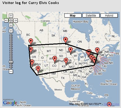
You must have at least three points to form a polygon, so obviously you must have at least three unique visitors before you can produce a home-range. Below is an example home-range for North America, for my Curry Elvis Cooks blog:


Map courtesy of Google Maps. Visitors plotted courtesy of gVisit.
What's the purpose of this? There are demographic applications for home-ranging your website or blogsite visitors. For example, over my multiple blogs, I have not had a single visitor from any African country yet. But African visitors have come to my main website. So then, if I wanted for some reason, more blog readers from African countries, I would presumably put some obvious hyperlinks from my main website to some or all my blogs.
Another application, if you are running multiple blogs, is to overlay home-ranges for each blog on a single map. Provided that you have sufficient visitors, over a reasonable time period (at least 3-6 months, preferably longer), then you have a suitable comparison of geographical basis for your blogs. It makes it easier for potential advertisers to decide which of your blogs they may want to advertise on.
You can also target your content, should you find that some blogs enjoy readership in a very small region. In this case, your home-range points should first be weighted. For example, over a period of a year, if a visiting city falls below a certain number of total visits, you can exclude this city from the home-range diagram. This is not a typical home range technique, but it is useful for demographic analysis of website/ blogsite visitors.
(c) Copyright 2005-present, Raj Kumar Dash, http://geoplotting.blogspot.com
The home-ranging concept can be extended to stationary points. For example, I can use a similar technique for home-ranging visitors to my blogsites. I haven't tagged all my visitors with radio chips yet, but I'm working on it :) For the meantime, I can convert their IP address to a city, which gives an approximate location for them.
You must have at least three points to form a polygon, so obviously you must have at least three unique visitors before you can produce a home-range. Below is an example home-range for North America, for my Curry Elvis Cooks blog:
Map courtesy of Google Maps. Visitors plotted courtesy of gVisit.
What's the purpose of this? There are demographic applications for home-ranging your website or blogsite visitors. For example, over my multiple blogs, I have not had a single visitor from any African country yet. But African visitors have come to my main website. So then, if I wanted for some reason, more blog readers from African countries, I would presumably put some obvious hyperlinks from my main website to some or all my blogs.
Another application, if you are running multiple blogs, is to overlay home-ranges for each blog on a single map. Provided that you have sufficient visitors, over a reasonable time period (at least 3-6 months, preferably longer), then you have a suitable comparison of geographical basis for your blogs. It makes it easier for potential advertisers to decide which of your blogs they may want to advertise on.
You can also target your content, should you find that some blogs enjoy readership in a very small region. In this case, your home-range points should first be weighted. For example, over a period of a year, if a visiting city falls below a certain number of total visits, you can exclude this city from the home-range diagram. This is not a typical home range technique, but it is useful for demographic analysis of website/ blogsite visitors.
(c) Copyright 2005-present, Raj Kumar Dash, http://geoplotting.blogspot.com
| Permalink | E-mail this post ![]()
![]()

You should check out our (more powerful) Google Maps stats service: MapStats.
Posted by Unknown |
12:56 PM
Unknown |
12:56 PM
Ahmed,
Thanks for the tip. I've signed up two sites to test out your service. Looks very cool. I'll blog about it in a few days :)
chameleon
Posted by blogslinger |
8:17 PM
blogslinger |
8:17 PM