|
|
 |
One of the first applications of GIS (Geographic Information Systems) packages was for home-ranging animal herds to determine their habitat. Another important application, since the mid-1980s, has been by police forces to track crime locations and to show geographic patterns. Criminals tend to be creatures of habit - pretty much like most human beings - and will stay within a certain territory - much like some animals. However, a more calculating crook might throw police of his/her trail by consciously breaking from habit. Nevertheless, by colour-coding crime scenes based on crime details and categories, it's often still possible to see patterns, especially by overlaying other coloured maps based on demographic data that applies to various geographic sectors. From all accounts in the GIS industry, police forces have been making excellent use of GIS packages and crime maps. In the United States, with several states now planning to affix GPS satellite-tracked devices on criminals on house arrest. History repeats itself, as police forces will no doubt be home-ranging such criminals to make sure that they stay within certain boundaries. (c) Copyright 2005-present, Raj Kumar Dash, http://geoplotting.blogspot.com Technorati : GIS, GPS, demographics, geographic data, geographic information systems, geoplotting
Read more...
GeoCommunity has a great treasure trove of links to free maps and DEM (Digital Elevation Maps) data. GIS.com, run by ESRI, also has a number of no-cost data and services, including the Hurricane Disaster Viewer, a slick-lookin, web-based map viewer showing New Orleans and various areas in the path of hurricanes. A question for any reader that cares to comment. What would you like to see more of here? I've noticed that even though this blog was originally going to focus on the "website visitors" aspect of GIS/Geographic Information Systems, people seem to be more interested in bits about geographically-related news and weather conditions. It may be a fluke, but it may not. That said, is anyone interested in learning about mapping projections? I spent 7 years working and researching in the GIS field from a computer programmer's point of view. I have stacks of notes and unpublished research papers lurking about. I even have a scribbled paper somewhere when I had to create my own formula to measure the distance between two points on Earth - which is an ellipsoid and not a perfect sphere. Anyone interested? Feel free to post a comment or drop me a line at rdash001-at-yahoo-dot-ca (email mangled to confuse spambots). (c) Copyright 2005-present, Raj Kumar Dash, http://geoplotting.blogspot.com
Read more...
") While one side of North America has been repeatedly battered by tropical storms, etc., the other side is suffering from forest fires for yet another year. (c) Copyright 2005-present, Raj Kumar Dash, http://geoplotting.blogspot.com Technorati : GIS, fire maps, free maps, geoplotting, maps, weather maps
Read more...
If you haven't already seen it, physorg.com, has a neat map showing the results of tracking several thousand cell phone users in Graz, Austria. This website also has a story on how the state of California in the United states plans to use GPS devices to track sex offenders, once they've been released. (c) Copyright 2005-present, Raj Kumar Dash, http://geoplotting.blogspot.com Technorati : geographic data, geoplotting, gis
Read more...
 For those of you on the road a lot or just gadget freaks, Navicom has a small new GPS device out that fits on your keychain. Just more proof that GPS devices are becoming household gadgets and aren't just for truckers, hikers, and wardrivers. (c) Copyright 2005-present, Raj Kumar Dash, http//geoplotting.blogspot.com Technorati : GIS, GPS, geographic, geolocation, geoplotting
Read more...
  Just a little aside for map junkies... The USGS (United States Geological Survey) has a regularly updated map that shows recent earthquake activity around the world. Now while it is logical when you consider plate tectonics, it's rather scary that the vast majority of earthquakes seem to be taking place along coastlines rather than, say, in the middle of the ocean. (c) Copyright 2005-present, Raj Kumar Dash, http://geoplotting.blogspot.com Technorati : earthquake maps, earthquakes, maps, usgs
Read more...
  [With apologies to Barret Strong, Norman Whitfield, Edwin Starr, authors of the song "War, What Is It Good For?"] Several weeks back, I was in a friend's car trying out my new, long-range wi-fi antenna for my laptop. We were planning to have dinner together, but it was early and E wanted to go for a drive. Still obsessed with my, then, new toy, I wanted to see how far it could pick up wi-fi network signals. E drove around in a loop of about 5 kilometres in diameter. In that time I picked up nearly 23 networks, the bulk of which had no security. The surprising thing was that many of the unsecured networks I picked up were part of professional organizations, school boards, and stores. I picked up one police network, but it was secured. I thought about trying to actually connect to some of the unsecured networks to see if they'd secured at a later stage, but E didn't stop the car long enough for me to bother. [Some networks, while appearing unsecured, don't actually allow you to get in without logging in with username and password on an internal web page. Organizations such as universities use this security model for their wi-fi networks.] Now while I knew that my activity was nothing I'd invented, I didn't realize that there's a name for it. It's called WarDriving or WiLDing. The activity is sometimes supplemented by using a GPS device to geo-locate each "public" network. The latitude/ longitude coordinates of the locations are then published either privately or publicly on special web pages. Reader Note: The images in this post are affiliate links created using Zoundry Blog Writer software. As I do not live in the United States and thus do not qualify for their Zoundry Service, I do not earn any commissions if you purchase any of the items shown here. However, Zoundry will earn the commissions, which is fine by me, in support for their great blogging software. (c) Copyright 2005-present, Raj Kumar Dash, http://geoplotting.blogspot.com Technorati : laptop antenna, laptop wi-fi, wardriving, wi-fi, wilding
Read more...
With the invention of the wi-fi laptop a few years ago, it's become harder to accurately track unique visitors to your website/ RSS feed/ blogsite visitors. Anyone who commutes a lot with a laptop may end up appearing as 3 or 4 different visitors in your web server access logs, possibly even as being from different cities. This of course inflates your readership/ subscriber numbers, which eventually may be something that advertisers, if you have any, may make you account for. While there is a new technique for identifying a computer anywhere geographically based each computer's unique clock skew, there's still the issue of accounting for Internet users that may use more than one computer in the course of a day. Browser cookies work if visitors are using one computer each day, but at different locations (i.e., at least with different IP addresses, if not also geographically). However, cookies are unreliable and may get deleted. Getting visitors to sign in works for some web sites, but may potentially reduce your readership if you force it upon everyone. Limited sign-on may be a better choice. For example, SlashDot lets anyone view their website, but you have to login to post a comment. You can datamine your web access logs and match them with logins, but only if every reader logins (not to mention, actually bothers to sign up). In limited situations, logins may work - say for membership-only type of content. Examples would be sites serving up online course material, e-books, etc. But where does that leave other websites? One sinister, almost Big-Brother-like possibility is to force all users to access the Internet with some sort of card (e.g., credit card) or RFID-chip-based device. Let's hope this never comes to pass. In the meantime, all we can do is make the assumption that each IP address represents a unique visitor and correct for this inaccuracy later, as we collect information through a variety of techniques. (c) Copyright 2005-present, Raj Kumar Dash, http://geoplotting.blogspot.com
Read more...
Over the past week, while trying out a number of different free visitor tracking services, I've noticed some interesting discrepancies. I access the internet from a number of different points. Depending on the tracking service I've used, one access point alternately shows up as either of two cities, neither of which I live in. The reason for this sort of thing is two-fold. First, a bit of background. At one time, the Whois database that tracked all domain registrations was a single database. Now, it's been spread out to over 100 copies, many of which do not agree with each other. In the course of business, Internet Providers may change their own nameserver information. Specifically, they may change the address information of where their nameservers live. So one Whois database might have one city registered for a particular IP address block, and another database may have a different city for the same block. What city a particular IP address gets converted now depends on what Whois database a particular visitor tracking service uses. And herein lies part of the secret of how I will hopefully, eventually, develop an IP-to-City conversion system in the postings of this blog. However, without manual editing, any such database that you build cannot possibly be 100% accurate, as IP address block information can and does change. (c) Copyright 2005-present, Raj Kumar Dash, http://geoplotting.blogspot.com
Read more...
After I posted yesterday's summary about some of the visitor tracking services available, Ahmed from BlogFlux left me a comment about their Google Map hack visitor tracking service, MapStats. They do the same as gVisit but also offer information about where a visitor came from before visiting one of your web/blog pages. What's more, they also offer several breakdowns of visit statistics. And they're free as well. I've already signed up and the first few visitors appear almost instanteously. There is some text on the tracking page that it can take up to 24 hrs to view information. On the two blogs I've been tracking, I have limited stats so far, so I'll see where we're at tomorrow. The kookiest thing I noticed on their demo pages was some statement saying that their domain name has been registered since 1969. Now unless they were part of the US Military networks, that's certainly not possible :) [Military "internets" have been around since the early or mid-1960s.] BlogFlux also has a "human-edited" directory of blogs, a pinging service, and more. Check them out. I'll post a bit more indepth about their services after a week or two. So far, I like what I see. I'm almost tempted not to write my own tracking package, but I have (custom) needs :) (c) Copyright 2005-present, Raj Kumar Dash, http://geoplotting.blogspot.com
Read more...
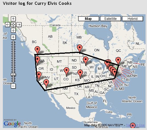
Scientists who study animal habitats use a technique in GIS (Geographical Information Systems) called home-ranging. Animals are tagged with radio-frequency devices, the positions of which can be captured by satellite. Over time, each animal in a herd gets tagged, and scientists can determine what part of a plain, a forest, etc., that that herd tends to inhabit. Usually, a map is plotted with all the tracked positions, then a convex hull is drawn. A convex hull is the smallest polygon that can be drawn so that its vertices are some of the tracked positions, while all remaining positions are inside of or on the polygon. The home-ranging concept can be extended to stationary points. For example, I can use a similar technique for home-ranging visitors to my blogsites. I haven't tagged all my visitors with radio chips yet, but I'm working on it :) For the meantime, I can convert their IP address to a city, which gives an approximate location for them. You must have at least three points to form a polygon, so obviously you must have at least three unique visitors before you can produce a home-range. Below is an example home-range for North America, for my Curry Elvis Cooks blog:  Map courtesy of Google Maps. Visitors plotted courtesy of gVisit. What's the purpose of this? There are demographic applications for home-ranging your website or blogsite visitors. For example, over my multiple blogs, I have not had a single visitor from any African country yet. But African visitors have come to my main website. So then, if I wanted for some reason, more blog readers from African countries, I would presumably put some obvious hyperlinks from my main website to some or all my blogs. Another application, if you are running multiple blogs, is to overlay home-ranges for each blog on a single map. Provided that you have sufficient visitors, over a reasonable time period (at least 3-6 months, preferably longer), then you have a suitable comparison of geographical basis for your blogs. It makes it easier for potential advertisers to decide which of your blogs they may want to advertise on. You can also target your content, should you find that some blogs enjoy readership in a very small region. In this case, your home-range points should first be weighted. For example, over a period of a year, if a visiting city falls below a certain number of total visits, you can exclude this city from the home-range diagram. This is not a typical home range technique, but it is useful for demographic analysis of website/ blogsite visitors. (c) Copyright 2005-present, Raj Kumar Dash, http://geoplotting.blogspot.com
Read more...
Some of this info has been mentioned in my other blogs, but here's a summary of some of the services available for "geo-plotting" your website and blogsite visitors: gVisit is a very cool Google Map Hack that shows which cities of the world each visitor is from. It only shows a maximum of 20 visitors at a time, so older visitors disappear. There's even an RSS feed available with latitude/ longitude coordinates for each visitor. The reporting is not real-time, but this service is very satisfying to watch (obsessively :). Eighteen year-young genius Kailash Nadh of ultra-fast Blog pinging service, Pingoat, has a bit of Perl code available to convert IP addresses to countries. His database comes from IP-to-Country, who have PHP sample codeMaxmind also has a free IP-to-country database and sample code in Perl, PHP, C, and Java. If you haven't seen it yet, check out Google Maps. If you want to write your own web scripts to write "Map Hacks" and display the results using Google Maps, you need to sign up for a Maps API. (c) Copyright 2005-present, Raj Kumar Dash, http://geoplotting.blogspot.com
Read more...
One of the concepts that we are going to be revisting several times in this blog is the conversion of IP addresses to the corresponding country code. From a standard, two-letter country code, we can derive country names. The reason this is relatively easy to do is because every country is assigned a one or more blocks of consecutive IP addresses. The current IPV4 (IP Version 4) protocol uses IP addresses that have four parts. An example is 127.0.0.1, which is a reserved address that actually refers to your personal computer, which is also known as "localhost". There are also reserved blocks of IP addresses that you can use to setup a home or office network. These addresses, because they are internal to a network, can be reused all over the world. Each of the four parts of an IP address can be from 0 to 255. Consecutive blocks can occur on any of the four parts. The larger a country is, the bigger the block. For example, a big country may have a block such as 144.0.0.0-159.255.255.255 assigned to them. This block represents (159-144)x255x255x255 = (15)x16,581,375 = 248,720,625 Internet addresses. A small country may have a block such as 160.0.0.0-160.0.255.255, which is (255x255) = 65,025 addresses. Countries are allowed to have more than one block. Since blocks of IP addresses have been pre-assigned to every country, provided you have acccess to this assignee list, it's easy to determine what country a visitor to your website or blogsite is from. Determining the city they are from is a bigger effort, but it is also possible. However, current efforts are reported to have a 95-98% accuracy. The methods used to produce an IP-to-City list are closely guarded secrets. But if you have the patience, I'm hoping to reveal that information in this blog. Note that the websit.es that I have downloaded IP-to-Country lists from have a TOS (Terms of Service) that states their list not be redistributed. However, there are ways to produce your own list, which I will reveal As it takes me a bit of research and testing to write each posting, I am probably only going to be posting to this blog once or twice a week until I have some research completed. Perl or PHP scripts will, as I've mentioned before, be made available at the Perl-Tips or PHP-Tips blogs, as available. (c) Copyright 2005-present, Raj Kumar Dash, http://geoplotting.blogspot.com
Read more...
When someone visits your website or blogsite, your web server records information in a log file. This log file is a rich source of information, which I'll be referring to repeatedly, especially in my Perl-Tips blog. Note: For those of you that have a blog hosted on a web server which you have no control over, don't fret. There are several ways you can track visitors. I'll discuss several methods in future posts. In fact, the assumption in this post is that you do not have access to your blog's web server log file. In this post, Part I, I present a method originally called "pixl tracking". The concept is very simple, and was used in HTML-formatted emails for Internet marketers to detect if and when an email was opened. What you do is place any suitable image file on your blogsite such that it will be accessed by any page of your blogsite, including archived pages. The image does not have to be visible, but I use my profile photo on my Blogger blogs. Each time your image is accessed, this is recorded in the web server log of the web site where your image resides. While this method is easy to implement, there are a number of flaws: - The biggest flaw with this is that the image has to live on a web server where you have access to the server log file. If you don't have your own web domain, or a friend with one, you'll have to use another method.
- You only get the IP address and the date/time/zone. This method does not tell you where visitors are coming from (i.e., the referring web page).
As mentioned above, I'll present other techniques in future posts. (c) Copyright 2005-present, Raj Kumar Dash, http://geoplotting.blogspot.com
Read more...
|
|
|
|
|
GeoPlotting Journal
This weblog/journal deals with a variety of topics relating to geographical data, as well as
GIS (Geographical Information Systems) software and GPS devices. Posting is currently suspended, until a new version of this journal
has been developed.
About Me
I'm a geek/ philosopher/ composer/ artist/
cook/ photographer/ web programmer/ consultant/ blah-blah-blah who is also a published writer and author. I worked with GIS
systems and cartographic projections for seven years. I've had a love of maps and globes ever since my father gave me an atlas
when I was in grade school. This is one of several blogs that I write.
|
| |
|
|
| |
|
|
|
|
|